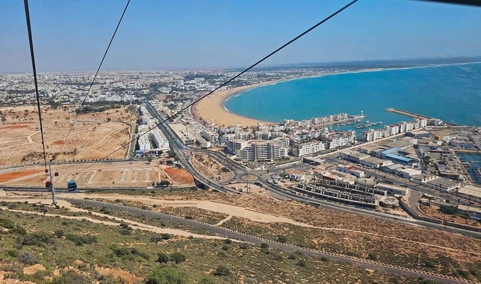
Agadir location

Agadir infrastructure and urban development—what matters for property

Assess Agadir’s infrastructure and urban development: airport, roads, neighbourhoods, utilities, everyday life, construction projects and effects on property locations.

View across Agadir and its urban structure on the Atlantic coast

Direct answer

A clear guide to Agadir infrastructure and urban development—what matters for property

Infrastructure and urban development affect how well a property in Agadir functions in everyday life. For buyers, actual routes to the airport, work, shops, healthcare and leisure matter just as much as roads, public transport, parking, water, electricity and digital connectivity. Public programmes and announced projects provide context but do not guarantee timing, delivery or appreciation. A location decision should therefore distinguish between infrastructure already in use, work in progress and planning alone. DACHMA can compare micro-locations and everyday routes on site; technical planning, legal and investment decisions remain with the competent authorities and specialists.

Agadir comprises very different residential locations: the coastal axis, Founty and Sonaba, Talborjt, Hay Mohammadi and other urban and peripheral areas each have their own transport and amenities profiles. A short distance on the map may feel different because of main roads, building sites or missing pavements. Buyers should view infrastructure not merely as a future promise, but test it within their personal weekly routine and consider the possible burden of development.

Official guidance: Haut-Commissariat au Plan – Housing statistics 2024 . The linked body does not replace an individual review.

Review points

Five decisions that make the difference

01

Airport and interregional connections

Agadir Al Massira Airport is relevant to many second-home and holiday users. The decisive factors are not only flight services, but actual driving time, transfer arrangements and travel times. Official ONDA information provides guidance. Future expansion announcements are taken into account only once their scope and schedule have been reliably confirmed.

02

Roads, traffic and walking routes

Main roads, junctions, parking, pavements and traffic at different times shape everyday life. Buyers test typical routes rather than straight-line distances alone. A quiet weekend viewing may conceal weekday conditions. In new-build areas, incomplete access roads and construction phases are also documented.

03

Districts and local amenities

Groceries, pharmacies, medical services, schools, restaurants, sport and beach access have different importance depending on the household. The quality of a micro-location arises from accessible everyday destinations, not a well-known neighbourhood name. Seasonal opening times and personal mobility form part of the assessment.

04

Utilities and building operation

Water, electricity, drainage, internet, the lift and communal technical systems are reviewed at the specific building. A new road says nothing about the condition of utilities or building management. In growing neighbourhoods, capacity, construction work and transition phases can raise additional questions requiring technical assessment.

05

Announcement, construction phase and existing state

Public projects are distinguished by source, approved scope, current status and geographical proximity. Buyers consider potential benefits and burdens such as noise, traffic or a changed view at the same time. A planned project is not included in the purchase calculation as certain appreciation or guaranteed completion.

Process

From the initial objective to a regulated next step

01

Clarify the objective and budget

For the ‘Agadir infrastructure and urban development’ project, intended use, region, property type, timeframe and total costs are defined in writing.

02

Narrow the search area

Determine micro-locations, everyday life, exclusion criteria and realistic alternatives.

03

Listings and viewing

Pre-filter information, consolidate appointments and document observations in a traceable manner.

04

Price and documents

Negotiate terms and have ownership, encumbrances, construction, use and costs reviewed separately.

05

Contract and payment

Coordinate the notary, specialist advisers, bank, deadlines, payment route and handover unambiguously.

06

Handover and management

Organise keys, the report, utilities, defects, inspections and letting as needed.

State risks realistically

What must be clarified before making a commitment

The greatest risk is justifying today’s price with an uncertain expectation of the future. Sales documents may present planned roads, parks or transport links as though they were already complete. Conversely, construction phases can create temporary or permanent disruption. City-level infrastructure also says little about access, parking, utilities and the community of an individual building. Buyers should consult official sources, inspect what currently exists and calculate several development scenarios. DACHMA does not promise completion, accessibility, appreciation or an unchanged view.

Professional limitations remain visible

Due diligence and coordination reduce information gaps. They replace neither individual review nor the responsibility of the relevant specialists.

Next step

Submit a qualified enquiry

State your regular routes, mode of mobility, travel frequency and two preferred districts. During viewings, journey times, walking routes, building sites, amenities and building operation are compared using a consistent protocol. Assumptions about the future remain separate from the condition verifiable today.

Submit the search profile

Decision-making in practice

Questions before committing: Agadir infrastructure and urban development — what matters for property

A sound purchase process combines several perspectives. A financially appropriate price is insufficient if ownership, use or condition remains unresolved. Conversely, a legally sound property does not automatically become the right choice if the location, everyday life and ongoing costs do not suit the buyer. Facts, assumptions and personal preferences are therefore documented separately.

Before making a reservation, it should be clear which documents are already available, which reviews remain open and who will undertake them. Every assurance receives a source or remains expressly marked as an assumption. This applies particularly to rental potential, renovation, construction progress, permissions and future infrastructure. Decisions under artificial time pressure do not fit this approach.

What DACHMA contributes specifically

DACHMA structures German-language communication, assists with selection and viewings, prepares negotiation and due-diligence questions, and coordinates agreed steps through to handover. The responsibility of external specialists remains visible. The buyer therefore knows who made a statement and what its scope is. This transparency is more important than a blanket promise that everything has been ‘verified’.

How a decision is documented

For serious candidates, advantages, unresolved points, costs, documents, responsibilities and deadlines are brought together. A decision follows only when material risks are understood. This may mean requesting further documents, commissioning a technical inspection, renegotiating terms or stepping away from a property. Ending the process can also be a good outcome.


Sources and professional limitations

Information as at 19 July 2026. The following bodies provide general guidance on the land register, notarial matters, finance or the respective location.

The information provides guidance and does not replace individual notarial, legal, tax, technical or financial advice.

Frequently asked questions

Frequently asked questions: Agadir infrastructure and urban development — what matters for property

Which infrastructure is particularly important for property buyers in Agadir?

That depends on intended use and everyday life. For second homes, the airport, key service and shopping may matter; permanent residents also need to consider work, healthcare, schools and daily mobility. For every property, access, parking, water, electricity, internet and building systems are added.

How far is the airport from a property?

This must be checked for the exact address, time of day and transfer type. Official airport information confirms the location and operation, not the personal journey time. Buyers test the route under realistic conditions wherever possible and account for waiting, parking or collection arrangements.

Does new infrastructure definitely increase property value?

No. The impact, timing, demand and expectations already reflected in prices are uncertain. A project can create benefits while also changing traffic or noise. A purchase decision should remain viable without guaranteed appreciation and give appropriate weight to the property’s current condition.

How do I assess a neighbourhood with many construction sites?

Document active projects, working hours, access routes, dust, noise and the visible stage of completion. Do not be guided by visualisations alone. Check which statements are officially confirmed and whether the property remains usable during an extended construction phase.

Do new residential areas automatically have better infrastructure?

Not necessarily. Modern planning can offer advantages, but roads, local amenities, the community and technical handover may still be developing. Older neighbourhoods can have established services but different building risks. The specific micro-location and residential development decide.

Can DACHMA reliably predict infrastructure projects?

No. DACHMA can bring together official information and observations and test routes on the ground. Decisions, dates and implementation lie with the responsible organisations. Future infrastructure, views and price trends are not guaranteed.

Geographical orientation

Choose a Moroccan city to suit your daily life

The cities are positioned using their geographical coordinates. The High Atlas is marked as a landscape region, while Midelt lies farther east at the transition between mountain regions.

Compare all locations Boundary geometry: Natural Earth · no external map trackers
Map of Morocco showing selected cities and the High AtlasGeographically projected orientation map showing Tangier, Tetouan, Rabat, Casablanca, Meknes, Fez, Midelt, Marrakech, Essaouira and Agadir.High AtlasTangierTetouanRabatCasablancaMeknesFezMideltMarrakechEssaouiraAgadir
Panoramic view across Agadir and the Atlantic coast as the backdrop to the property enquiry

Personal initial consultation

Ready to find your property in Agadir?

Send your profile in just a few steps – confidentially, in a structured format and with personal attention.

Start an enquiry

Non-binding enquiry · No guarantee regarding returns, legal matters or tax · Reply usually within 1–3 working days

Enquire now!